
OLD INLET BREACH FLYOVER 2017-04-09
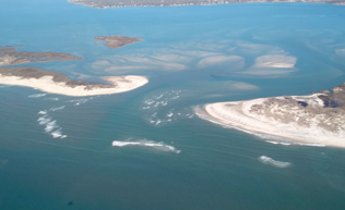
 Dr. Charles Flagg took another flight over the Breach at Old Inlet on Fire Island on April 9, 2017. The flyover mosaic is available below. Dr. Flagg provided the following report:
Sunday April 9th was a clear and low wind day and perfect for another aerial photo run to the breach.
The flight took place around 10 am EDT, during a rising tide in the bay and near mid-tide in the ocean. The apparent retreat of the eastern shoreline by some 50 meters relative to the March photo appears to be mostly the result of the differences in tidal stage and the gradually slope of shore there. Overall, the situation looks much as it did in March but there are some subtle changes appearing in the channels through the breach. Most important is the continuing shift in the main channel through the breach. For some time the main channel passed just south of Pelican Island, out along the western shore and then, oddly, discharging into the ocean toward the east. In the last couple of months there appears to be a greater amount of flow along the north shore of eastern Fire Island. In the past, this pathway was blocked by the shoals in the breach. But those shoals look to be eroding while there has been a build-up of a shoal just south of Pelican Island. Those changes seem to be shifting the main channel to the south. While this change occurred in the breach, in the past month the discharge channel through the ebb shoal has shifted to a more southerly orientation, perhaps as a result of the recent nor’easters we have experienced.
Mark Lang has assembled all the geo-referenced photo mosaics into a kml file that can be viewed using Google Earth. By clicking between images and using the fade in-out button you can clearly see how the inlet is changing with time. An offline version of the KML file is available as KMZ.
For more information, please visit Dr. Charles Flagg’s website.
Leave a Reply