
Storm Surge
FEMA Family Communication Plan for Children
FEMA Family Communication Plan for Parents
![]()
Are You Prepared?
Get Prepared
Download the FEMA App
Know your Evacuation Zone
Make a Plan & Be Ready
Stay Informed
Forecast Hurricanes | Weather
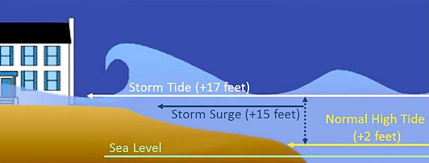
Storm surge is an abnormal rise of water generated by a storm, over and above the predicted astronomical tides. Storm surge should not be confused with storm tide, which is defined as the water level rise due to the combination of storm surge and the astronomical tide. This rise in water level can cause extreme flooding in coastal areas particularly when storm surge coincides with normal high tide, resulting in storm tides reaching up to 20 feet or more in some cases.
Factors Impacting Surge
Storm surge is produced by water being pushed toward the shore by the force of the winds moving cyclonically around the storm. The impact on surge of the low pressure associated with intense storms is minimal in comparison to the water being forced toward the shore by the wind.
The maximum potential storm surge for a particular location depends on a number of different factors. Storm surge is a very complex phenomenon because it is sensitive to the slightest changes in storm intensity, forward speed, size (radius of maximum winds-RMW), angle of approach to the coast, central pressure (minimal contribution in comparison to the wind), and the shape and characteristics of coastal features such as bays and estuaries.
Other factors which can impact storm surge are the width and slope of the continental shelf. A shallow slope will potentially produce a greater storm surge than a steep shelf. For example, a Category 4 storm hitting the Louisiana coastline, which has a very wide and shallow continental shelf, may produce a 20-foot storm surge, while the same hurricane in a place like Miami Beach, Florida, where the continental shelf drops off very quickly, might see an 8 or 9-foot surge. More information regarding storm surge impacts and their associated generalizations can be found in the FAQ section.
Adding to the destructive power of surge, battering waves may increase damage to buildings directly along the coast. Water weighs approximately 1,700 pounds per cubic yard; extended pounding by frequent waves can demolish any structure not specifically designed to withstand such forces. The two elements work together to increase the impact on land because the surge makes it possible for waves to extend inland.
Additionally, currents created by tides combine with the waves to severely erode beaches and coastal highways. Buildings that survive hurricane winds can be damaged if their foundations are undermined and weakened by erosion.
In confined harbors, the combination of storm tides, waves, and currents can also severely damage marinas and boats. In estuaries and bayous, salt water intrusion endangers the public health, kills vegetation, and can send animals, such as snakes and alligators, fleeing from flooded areas.
Notable Surge Events
Ike 2008
Hurricane Ike made landfall near the north end of Galveston Island as a Category 2 hurricane. Storm surges of 15-20 feet above normal tide levels occurred along the Bolivar Peninsula of Texas and in much of the Galveston Bay area. Property damage from Ike is estimated at $24.9 billion.
Katrina 2005
Katrina was one of the most devastating hurricanes in the history of the United States. It produced catastrophic damage – estimated at $75 billion in the New Orleans area and along the Mississippi coast – and is the costliest U. S. hurricane on record. Storm surge flooding of 25 to 28 feet above normal tide levels was associated with Katrina.
Dennis 2005
Dennis affected much of Florida, and its effects extended well inland over portions of the southeastern United States with the maximum amount rainfall of 12.80 inches occuring near Camden, Alabama. Storm surge flooding of 7-9 ft produced considerable storm surge-related damage near St. Marks, Florida, well to the east of the landfall location. The damage associated with Dennis in the United States is estimated at $2.23 billion.
Isabel 2003
Isabel was the worst hurricane to affect the Chesapeake Bay region since 1933. Storm surge values of more than 8 feet flooded rivers that flowed into the bay across Virginia, Maryland, Delaware, and Washington, D.C. Isabel was the most intense hurricane of the 2003 season and directly resulted in 17 deaths and more than $3 billion in damages.
Opal 1995
Hurricane Opal made landfall near Pensacola Beach, Florida as a Category 3 hurricane. The storm caused extensive storm surge damage from Pensacola Beach to Mexico Beach (a span of 120 miles) with a maximum storm tide of 24 feet, recorded near Fort Walton Beach. Damage estimates for Opal were near $3 billion.
Hugo 1989
Hugo impacted the southeastern United States, including South Carolina cities Charleston and Myrtle Beach. Hugo was responsible for 60 deaths and $7 billion in damages, with the highest storm surge estimated at 19.8 feet at Romain Retreat, South Carolina.
Camille 1969
Camille was a Category 5 hurricane, the most powerful on the Saffir-Simpson Hurricane Wind Scale with maximum winds of more than 155 mph and storm surge flooding of 24 feet that devastated the Mississippi coast. The final death count for the U.S. is listed at 256. This includes 143 on the Gulf coast and another 113 from the Virginia floods.
Audrey 1957
There were 390 deaths associated with Audrey as the result of a storm surge in excess of 12 feet, which inundated the flat coast of southwestern Louisiana as far as 25 miles inland in some places.
New England 1938
The Long Island Express was a fast-moving Category 3 hurricane that struck Long Island and New England with little warning on September 21. A storm surge of 10 to 12 ft inundated the coasts of Rhode Island, Connecticut, southeastern Massachusetts, and Long Island, NY, especially in Narragansett Bay and Buzzards Bay. Six hundred people died due to the storm.
Galveston 1900
At least 8,000 people died when hurricane storm tides (the surge plus the astronomical tide) of 8-15 feet inundated most of the island city of Galveston, TX and adjacent areas on the mainland.
Surge Vulnerability Facts
From 1990-2008, population density increased by 32% in Gulf coastal counties, 17% in Atlantic coastal counties, and 16% in Hawaii (U.S. Census Bureau 2010)
Much of the United States’ densely populated Atlantic and Gulf Coast coastlines lie less than 10 feet above mean sea level
Over half of the Nation’s economic productivity is located within coastal zones
72% of ports and 27% of major roads and 9% of rail lines within the Gulf Coast region are at or below 4 feet elevation.
A storm surge of 23 feet has the ability to inundate 67% of interstates, 57% of arterials, almost half of rail miles, 29 airports, and virtually all ports in the Gulf Coast area.
Source: NOAA
Leave a Reply